Vessel
Calibration.
MTK Surveys and Engineering Limited partnered with C & C Technologies to perform a Deepwater Geophysical and Geotechnical Survey for our Client.
Vessel Calibration
This procedure was carried out at the Sekondi Naval Base. Activities include but is not limited to Vessel Gyro Calibration. This was performed to accurately determine the misalignment angle between the gyro’s north and the local north of the coordinate system of the vessel which will make it possible to accurately transfer the horizontal element of our vessels local reference frame into a global reference frame.
Allowing the entire survey system to benefit from the
accuracy of the Gyro. Other Tasks included Vessel Heading and DGPS Health Checks.
The successful completion of the aforementioned tasks enabled actual Geophysical and Geotechnical works to commence.
Deepwater Geophysical and Geotechnical Survey
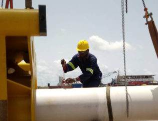
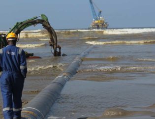
The main scope of works was conducted offshore aboard the Rig Supporter with the aid of an AUV (Autonomous Underwater Vehicle). The box corer was deployed for the seabed sampling which constituted the Geotechnical aspect of the scope.
All Tasks were conducted and performed in a systematic and structured manner allowing data collected to be top notch in quality and accuracy. This enabled the client in making vital
decisions and allowed other tasks be conducted accurately.
Case Study
Vessel Gyro Calibration. MTK in collaboration with C & C Technologies to performed a Deepwater Geophysical and Geotechnical Survey. Allowing the entire survey system to benefit from the accuracy of the Gyro.